- About UsMeet the staff members from the Parks and Recreation Department.
- Accounts Payable
- Accounts Receivable
- Action Center
- Active Adult CenterOur Senior Center plays an important role in connecting seniors not only to friends and fun, but to services and resources in the community around them.
- AdministrationThe department administration includes the Chief of Police, Deputy Chief of Police, and Operations Commander / Uniform Commander.
- Agendas & Minutes
- Amphenol/Franklin Power Products in Franklin, Ind.
- Automatic Utility Bill PaymentUse this ACH form to arrange for automatic payment of your sewer utility bill.
- Available Industrial Sites
- Beeson HallBeeson Hall is the premier location for your next catered special event, located on the southwest corner of the Cultural Arts and Recreation Center, 396 Branigin Blvd., Franklin.
- Birth and Death Records
- Blog Posts
- Board of Public Works and Safety
- Board of Zoning AppealsThe Board of Zoning Appeals meets the first Wednesday of each month at 6:00 p.m.
- Boards & Commissions
- Breaking News
- Budgets
- Building & Construction
- Building Permits and Inspections - City of Franklin, IndianaAll building inspections must be scheduled with the Department of Planning & Economic Development at least one (1) business day before the inspection is to be conducted. Inspections will not be scheduled for more than five (5) days in advance.
- Business
- Chamber of Commerce
- Citizen Assesment Survey
- City Code
- City CouncilThe City of Franklin Common Council consists of seven members who serve as the legislative branch of the City of Franklin. The members are elected by voters in their district and each member serves a four-year term. The city council meets the first and third Monday of each month at 6:00 p.m. Meetings are open to the public, and held in City Hall, located at 70 E. Monroe Street.
- City CourtThe City Court handles criminal misdemeanors, traffic infractions and city ordinance violations. Court sessions are held Mondays beginning at 9:00 a.m. and 1:30 p.m. in the Court Chambers and are presided over by City Court Judge K. Mark Loyd FORMS OF PAYMENT ACCEPTED: CASH, MONEY ORDER AND DEBIT OR CREDIT. IF YOU USE A DEBIT OR CREDIT CARD IT WILL CHARGE YOU $4.00 PLUS 2%.
- City Master PlansCity of Franklin Master Plans
- Clear Water Reduction Program
- Clerk-TreasurerThe primary function of the Clerk-Treasurer, a four-year elected official, is to serve as the fiscal officer of the City of Franklin. The Clerk-Treasurer manages City expenses, payment methods, investments, is responsible for all aspects of the budget and manages all City records.
- Code Enforcement: File a complaint
- Code Enforcement
- Commercial & Industrial Site Plan Review
- Community DevelopmentThe department is responsible for facilitating the vision of the City of Franklin Comprehensive Plan and the Redevelopment Commission's Strategic Plan. The department provides planning, redevelopment, economic development and community development services.
- Community Event Listing Request
- Community Event Registration Form
- Community
- Comprehensive PlanThe 2013 City of Franklin Comprehensive Plan was officially adopted by the Franklin Common Council on October 7, 2013.
- Crime Tip Line
- Departments
- Dining
- Discover Downtown Franklin
- Diversity/Equity/Inclusion Plan
- Document Center
- Dog ParkThe City of Franklin Dog Park is located within Province Park. Membership forms are available online and should be submitted to the Franklin Parks and Recreation Department.
- DPW Customer ServiceThe Department of Public Works Customer Service welcomes your feedback. Whether a concern or good experience, the information you provide helps us to serve our customers better in the future.
- Drainage Issues
- DriveHubler.com Amphitheater
- Economic Development CommissionEconomic Development efforts for the City of Franklin are coordinated by the City's Community Development Department. The Commission oversees Tax Abatement, Economic Development Revenue Bonds, Tax Increment Financing, Lease & Purchase Agreements, and Historic Tax Credits.
- Economic Development
- Education
- Elected Officials
- Employee Portal
- Employment
- Events Calendar
- Facility ReservationsReservations and rentals for facilities operated by the Franklin Parks and Recreation Department can be made at the Parks Administrative Office located in the Cultural Arts & Recreation Center. There are 14 facilities to chose from that offer a variety of amenities.
- Fats, Oils & Grease Program
- Fire Department Educational Services & PR Request Form
- Fire DepartmentThe City of Franklin is an all career Fire Department within Johnson County. The department is staffed with paramedics and EMT's to provide the highest level of emergency medical care to the the citizens of Franklin, in addition to fire suppression and rescue services.
- Fire MeritThe Fire Merit Commission's function includes the appointment, promotion, and discipline of Fire Department personnel.
- Fire Safety EducationFire prevention demonstrations offered for people of all ages.
- ForensicsThe Forensic Investigation Division investigates all pertinent crime scenes, anages the property room and has played a vital role in several homicide investigations.
- Forms & Applications
- Franklin College
- Franklin Family Aquatic CenterThe Franklin Aquatic Center includes an Olympic-sized pool with diving well, 190-foot water slide, a new zero depth pool with a play structure including 16 interactive play features, water basketball, concession stand, and sun decks. Lots of fun and relaxation for the entire family.
- Franklin Mayor's Youth Leadership Council
- Franklin Parks & Recreation
- Franklin's Zoning DistrictsA new zoning ordinance was adopted by City Council on May 10, 2004 and amendments incorporated as adopted. Property zoning can be found through the Beacon GIS Maps.
- Full-Time School Resource Officer
- General
- Government
- Greenlawn CemeteryThe City of Franklin's Greenlawn Cemetery is a municipally owned cemetery established in 1845 by Franklin's citizens.
- Historic Greenway Trails
- Home Page
- I Want To...
- Image Gallery
- Indiana Handgun Licensing InformationIndiana Handgun Licensing Application Process and documentation.
- Investigations
- Investment IncentivesThe Economic Development Commission oversee the investment incentives, which include; Economic Incentives, Economic Development Revenue Bonds, Tax Increment Financing, Lease & Purchase Agreements, Tax Abatement, and Economic Revitalization Areas or Target Areas.
- Ivy Tech Community College
- Job Postings
- Johnson County Parks
- Kickapoo Kids CampKickapoo Kids Camp Summer 2026
- Lifestyle
- Locations
- Maps
- Mayor's Office
- News & Notices
- Online Bill Payment
- Online Traffic Ticket PaymentLooking for a ticket? Want to pay a traffic ticket online? Tickets issued with the electronic ticketing software can be located and printed using this service. You may be able to pay your Franklin City Court ticket through their online system.
- Ordinances
- Our Town Players
- Park BoardPark Board meetings are held the third Thursday of each month beginning at 4:00 p.m. at the Franklin Cultural Arts & Recreation Center, located at 396 Branigin Blvd, Franklin. The meetings are open to the public.
- Park Facility Reservations
- Parks and RecreationFranklin Parks and Recreation is dedicated to providing the opportunity for all community residents to enjoy safe, affordable and well maintained recreational facilities and a variety of quality leisure activities.
- ParksFranklin Parks and Recreation offers a unique dedication program to honor and remember friends and relatives. Planting a tree in a city park is a wonderful way to honor a loved one and also provides a gift to the whole community.
- Pay Your Utility Bill OnlineAs a convenience to our customers-you can now view, print, or pay your utility bill online.
- Payment Center
- Payroll
- Permits, ReportsThe Franklin Police Department Records Division provides the following services to the City; Handgun Permits, Accident Reports, Incident Reports, VIN Inspections, Fingerprints, Limited Criminal History, and Photos & Videos.
- Permitting Portal - City of Franklin
- Plan Commission
- Planned Unit DevelopmentPlanned Development regulations are intended to encourage innovations in land development techniques so that the growing demands of the community may be met. Projects should also encourage a more efficient use of land which reflects the changes in the technology of land development so that resulting economies may accrue to the benefit of the community at large.
- Planning and EngineeringThe department is responsible for engineering, current planning, zoning, building inspections, and municipal code enforcement.
- Police Department CareersApplications for the Franklin Police Department will be accepted from June 11 through July 10.
- Police Department Vacation Watch RequestPolice Department Vacation Watch Request: notify the Police Department of your plans to be away from your home or business and to request that officers check on your home or business while you are away, not to exceed one week.
- Police DepartmentThe Police Department seeks to safeguard the lives and property of the people we serve, reduce crime, and enhance public safety to provide a safe atmosphere to raise families and promote business for generations to come.
- Police Merit Commission
- Programs/ClassesWe offer a wide variety of programs at the Cultural Arts & Recreation Center. If you are interested in getting fit, we have many aerobics classes including Yoga, Zumba, Cycle Fit, and more!
- Public Art Advisory Commission
- Public Records RequestThe City of Franklin agrees that all documents of the City of Franklin are public records and should be available for inspection and copying, with the exception of a few documents that are considered confidential under Indiana Code 5-14-3-4. Requests for public records will be reviewed during normal business hours.
- Public WorksThe department is responsible for coordinating and managing all public works including; billing, recycling, streets, and stormwater.
- Records
- Recreation & Fitness CenterThe Cultural Arts & Recreation Center at 396 Branigin Boulevard offers 30,000 square feet of space for programs and activities offered by our department. Our Fitness Center is available for those who want a challenging workout and is ideal for anyone wanting to tone up and gain strength.
- Redevelopment CommissionThe Redevelopment Commission meets the 3rd Tuesday of each month at 8:00 a.m. in the Council Chambers at City Hall - 70 E. Monroe Street.
- Related Links
- Related Pages
- Report a Pothole
- Report an abandoned vehicle
- Reports
- Residents
- Resolutions
- RezoningOwners of parcels of land within the City of Franklin, and inside her "buffer zone" may request their property be changed to a different zoning district. The Franklin Common Council review and approval all rezoning requests.
- Services Index
- Shopping
- Sidewalk Replacement ProgramThe Street Department oversees the Sidewalk Replacement Program. In August 2009, Ordinance No. 09-10 establishing a program for the repair and replacement of sidewalks within the public ways of the City of Franklin.
- Sister CitySince October of 1960 Kuji, Japan has been our sister city. Since our bond was established we have made multiple trips to visit Kuji, including a recent trip in 2017.
- Solid Waste / RecyclingThe City of Franklin Department of Public Works has outsourced the collection of solid waste/trash and recycling services to Ray's Trash Service.
- Solid Waste/Recycling
- Special Events
- Staff Directory
- Stay InformedThe City of Franklin utilizes various streams of communication to stay connected with the community. Check out Facebook, Twitter, and the City site for current details.
- Storm Water Awareness Survey
- StormwaterThe Storm Water Management Utility is tasked with providing the safe, economical, and efficient management and protection of the City of Franklin's storm water conveyance system to our receiving waters.
- Street Cut PermitsThe City of Franklin coordinates permits for street cuts. Please contact the Planning & Engineering Department offices to submit an application.
- Street DepartmentThe Franklin Street Department provides a variety of services in overseeing the City's infrastructure.
- Streetlight in Need of Repair
- Subdivision of LandThe Planning & Engineering Department along with Economic Development oversee the subdivision of land. Subdivision includes the division or development of land zoned for residential and non-residential uses, whether by deed, metes and bounds descriptions, devise, intestacy, lease, map, plat or other recorded instruments.
- Tax Abatement PolicyThe Economic Development Commission and Common Council oversees the Tax Abatement Policy & Decision Guidelines. These guidelines are meant to be used as both a starting point and standard format for general questions relating to tax abatement requests. These guidelines are not intended to be all inclusive. Based on the merits of each individual request, the Economic Development Commission and Common Council may deviate from established policies at their discretion.
- Technical Review Committee
- Technology CouncilThe Telecommunications Council meets on the Fourth Monday of the month at 5:30 p.m. in the conference room of City Hall, 70 E. Monroe St., Franklin, IN 46131.
- Tree Advisory CommitteeTree Advisory Committee meetings are held the fourth Thursdays of each month beginning at 5:00 p.m. at the Franklin City Hall, Council Chambers, located at 70 E Monroe Street, Franklin. The meetings are open to the public.
- Uniform Division
- Utility Billing OfficeThe Sewer Utility Office coordinates sewer utility billing for the City of Franklin.
- Vacation of an Alley or Public WayThe Planning Department and Board of Public Works and Safety partners with petitioners who wish to vacate all or part of a public way, the petition will be requested through the City Council.
- Visitors
- Voluntary Title VI Public Involvement Survey
- Wastewater Treatment PlantThe City of Franklin's wastewater treatment plant has been recognized with various awards for operational efficiency over the past several decades.
- Welcome To Franklin
- Zoning Ordinance
- Zoning VariancesThere are state required criteria that must be met in order for the Board of Zoning Appeals to be able to grant either variance. There are three criteria for a variance from developmental standards and five for a use variance.
- ZoningThe City of Franklin Technical Review Committee provides advice to the Plan Commission on issues requiring technical expertise.
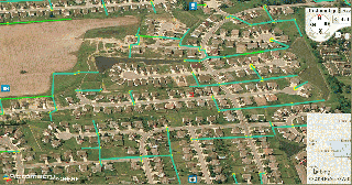
MS4 Program - Storm Sewer Mapping
As part of the Franklin's Illicit Discharge and Elimination minimum control measure, the city has developed a storm drain system map showing the locations of all outfalls and the names and locations of all waterbodies receiving those discharges. These maps are needed to help monitor dry weather flows to investigate potential pollutant discharge and it source. Throughout the year, MS4 personnel inspect outfalls and conduct stream monitoring based upon point source and non-point source pollution potential of all mapped outfalls. Should a discharge be discovered at an outfall, accurate mapping of the storm sewer system allows investigators to follow the pollution source.
Sources of illicit discharges may include illegal sewer hookups into the storm drain system, septic tanks, car wash or laundry washwater, improper disposal of motor oil or other household or auto fluids, or chemical spills.